


India’s Defense Minister Rajnath Singh has, at times, threatened to occupy Sindh and referenced “Operation Sindoor 2.0.”
Amidst this, an inflammatory statement emerged regarding Sir Creek, claiming, “Pakistan has expanded its military infrastructure near Sir Creek and if any adventurous action occurs there, India will respond in a ‘decisive’ manner that can ‘change history and geography.’” This signals India’s intent to open another front of aggression under the pretext of Sir Creek. But what is the dispute over Sir Creek that has led to these provocative statements?
In the 19th century, British thinker and parliamentarian John Bright famously stated, “FORCE IS NO REMEDY,” advocating peaceful dispute resolution. On June 24, 1857, he warned in the House of Commons that India was not a country but a region that should be divided into five sovereign parts or it would become a hotbed of conflict after British departure. This foresight materialized after August 15, 1947, when India witnessed widespread riots and the systematic genocide of Muslims. Beyond occupied Kashmir, Junagadh and Sir Creek exemplify the injustices perpetuated by the United Nations and the manipulations of British and Brahmin hegemony—yet very few people are fully aware of these issues.
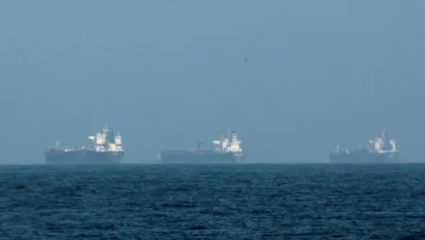
Historically, Sir Creek has been a century-old problem stemming from British-era disputes between Sindh and Rajasthan. Once called “Jan Ganga,” it was later named ‘Sir Creek’ by an English officer. Geographically, it is a marshy area in Sindh, also referred to as a bay, creek or branch and before partition, it was a habitat for aquatic birds. Its 96-kilometer waterway connects Gujarat and Sindh and became a disputed territory in the 1960s. Both countries are highly sensitive due to its extensive oil and gas reserves. One part is under Pakistan’s control, while India occupies another, maintaining naval facilities. All 17 creeks along the coastal strip belong to Pakistan, though India claims half of Sir Creek. Fishermen are regularly detained on both sides for alleged maritime violations, often straining bilateral relations.
Sir Creek’s strategic and economic significance is immense. Its marine life, mineral resources and defense position make it a critical area. Despite India occupying Kashmir, Junagadh, Siachen, Manavadar and Mangrol, it claims Sir Creek, although historically part of Sindh and awarded under the 1914 agreement. Indian leadership knows that in 1925, Sindh’s rights were recognized. Any international arbitration would likely favor Pakistan, as the Maharaja of Kutch had agreed to the boundary, which would require India to relinquish around 250 square miles.
Since 1964, bilateral talks have repeatedly attempted to resolve the dispute without success. The British government had settled the matter in 1914 between the Sindh Commissionery (under Bombay Province) and the Maharaja of Kutch, officially recognized through a Bombay Province resolution on May 24, 1914. Documents and maps were exchanged and boundary demarcation was mutually agreed. The United Nations Commission on the Law of the Sea urged countries to resolve maritime disputes by 2007 to settle claims by 2009. Resolution requires India to show flexibility, abandon the centerline claim of Sir Creek and move closer to Pakistan’s eastern bank proposal; otherwise, the dispute will persist.
The stakes go beyond territorial claims. Control over Sir Creek affects fishing rights, oil and gas extraction and Exclusive Economic Zones. Full control by one country could allow resources worth billions to be extracted, fundamentally altering the economic balance in the region. Following the 1965 war, the matter was referred to a tribunal, which on February 19, 1968, invalidated India’s claim over the entire Rann of Kutch, granting Pakistan only a small portion. In 2005, both countries began a joint survey. The BJP informed Foreign Minister Natwar Singh that the princely state of Kutch and Sindh officials had completed a survey in 1914 under the Bombay Presidency, erecting 67 boundary pillars, of which 56 remain. Partition left Sir Creek’s boundary unresolved. Pakistan maintains the border runs along the eastern bank, while India insists, under the Thalweg principle, it should run through the center of the channel. Recent Indian military exercises, named “Trishul,” along the western desert borders and extending from Sir Creek into the Arabian Sea, are described as the largest since “Operation Sindoor.” Pakistan Navy exercises in the northern Arabian Sea sent a clear message of readiness to respond decisively. Statements from Narendra Modi and his ministers are a failed attempt to distract from internal challenges and previous humiliations, using external aggression to consolidate political power ahead of elections. Incidents, such as orchestrated bomb blasts in Delhi before the Bihar Assembly elections, falsely blamed on educated Muslim youth, particularly Kashmiri doctors, illustrate attempts to manipulate public perception.
Driven by an obsession to become the regional hegemon, India continues efforts to weaken Pakistan, using both aggressive rhetoric and strategic posturing in contested areas like Sir Creek. The dispute is a mix of historical injustice, strategic importance and economic interests. Resolution requires India’s willingness to acknowledge past agreements, respect Pakistan’s claims and negotiate in good faith. Otherwise, Sir Creek will remain a flashpoint of regional tension, where historical grievances, strategic ambitions and economic opportunities collide.
It is essential for the international community to recognize the historical agreements and the strategic and economic stakes of Sir Creek. Failure to address this dispute could not only exacerbate India-Pakistan tensions but also disrupt regional stability. Pakistan’s firm stance, backed by historical documentation and international law, reinforces the validity of its claims and highlights India’s aggressive posture as a continuing threat to peace in South Asia.